Williams Gliderport (CN12)
Prior Permission Required
William's Gliderport is a private facility. Airplanes may not takeoff or land from this runway without prior permission. After you have coordinated and received permission to fly your airplane into Williams you will be expected to call once again on the day of your arrival.
Pilots
Pilots must comply with all applicable Federal Aviation Regulations (FAR's). Please be familiar with, and comply with all procedures. Williams Gliderport Information is subject to change.
The Pilot Information Form
Read the "General / Pilot Responsibilities section and be prepared to complete a Pilot Information Form and to acknowledge your understanding of the "Williams Soaring Center Pilot Operations" material when you visit the field. Your cooperation is appreciated.
[ Top of Page ]
Arrival in the Terminal Area and Traffic Pattern
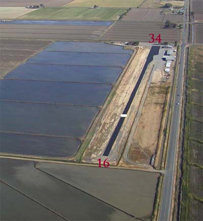
Both gliders and airplanes are instructed to fly the traffic pattern on the east side of the field.
 Left
traffic for Runway 16.
Right Traffic for Runway 34.
Enter Traffic pattern at 1,000 foot altitude.
Standard procedures, as stipulated in the Airman's Information Manual (AIM) are recommended. The patterns, as flown by the gliders are explained in detail in the Operations Section of this document.
Call on Frequency 123.3 not later than five miles out, and then make standard radio calls when in the traffic pattern.
Gliders should always be given the right-of-way.
Caution: Not all gliders have a radio.
Note: The fields in this photo do change visually depending on season and crops planted.
[ Top of Page ]
Landing and Taxiing
CAUTION PROP BLAST
Your prop blast can cause expensive damage
to glider finishes and glider canopies!
Gliders are staged on the south end of the field and will be departing to the north, even with a slight tailwind. Landing may be accomplished in either direction; however specific ground tracks are specified when landing to the north. See the Flight Operations section for further info on this and all other aspects of operations.
The grass runway is normally not useable during the wintertime, or if there has been any rain within the preceding 30 days. Use the paved surface for landing and taxi.
Back Taxi, 180 Degree Turns and Turning Off the Runway
If you land to the north, proceed all of the way to the north end of the field before attempting a 180 degree turn. The areas at midfield are normally too muddy to support an airplane if it is at all wet.
Parking
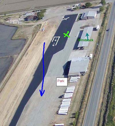
Parking will be as directed by management. Normally, the east side of the large mid-field hangar will remain clear, so do not park in that area. Depending on your length of stay you may be directed to the south end of the field, near the office, or to the north end of the covered parking area (but south of the refueling area that is south of the hangar) or you will be asked to park near the trailers, which are lined up just north of the big hangar.
If you do park near the trailers, move the airplane by hand, facing east, with the tail close to the trailers. Upon departure, you will need to once again move the airplane by hand and face south before starting.
 This
image shows the expected track of a glider
landing to the north, therefore, be sure
to park close to the trailers, just north
of the hangar, (white square with 'PARK')
if asked to park in that area.
[ Top of Page ]
Departure
All departures are normally conducted to the north. Advise the office and the line personnel if you are planning to depart. They may be able to tell you what operations are scheduled to launch in the immediate future, and how many gliders are currently in the air. Be sure to accomplish a positive scan of both a right and left pattern (both downwind and base legs) before you initiate your takeoff roll. You should expect to have opposing traffic landing opposite to the direction of your takeoff.
www.AirNav.com Information Williams Gliderport CN12
Airport information is available at: http://www.airnav.com/airport/CN12
The Air Nav website runway Traffic Pattern and Phone number is WRONG. Contact Williams Gliderport at 530-473-5600.
See "Arrival in the Terminal Area and Traffic Pattern" above for landing traffic patterns. (All landing patterns are on the East side of gliderport, LEFT for Runway 16, RIGHT for Runway 34)
Location
FAA Identifier: |
CN12 |
Lat/Long: |
39-09-48.6080N / 122-07-53.9080W |
Elevation: |
68 ft. / 21 m (estimated) |
Variation: |
16E (1985) |
From city: |
1 mile NE of WILLIAMS, CA |
Time zone: |
UTC -7 (UTC -8 during Standard Time) |
Zip code: |
95987 |
Gliderport Operations
Gliderport use: |
Private use. |
Sectional chart: |
SAN FRANCISCO |
Control tower: |
no |
ARTCC: |
OAKLAND CENTER |
FSS: |
RANCHO MURIETA FLIGHT SERVICE STATION |
Attendance: |
UNATNDD |
Wind indicator: |
yes |
Segmented circle: |
no |
Landing fee: |
yes |
Nearby radio navigation aids
VOR radial/distance |
|
VOR name |
|
Freq |
|
Var |
ILA r301/7.4 |
|
WILLIAMS VORTAC |
|
114.40 |
|
18E |
MXW r138/10.1 |
|
MAXWELL VORTAC |
|
110.00 |
|
18E |
MYV r263/26.3 |
|
MARYSVILLE VOR/DME |
|
110.80 |
|
16E |
CIC r183/39.8 |
|
CHICO VOR/DME |
|
109.80 |
|
16E |
|
NDB name |
|
Hdg/Dist |
|
Freq |
|
Var |
|
ID |
|
|
214/30.9 |
|
212 |
|
16E |
|
OVE |
--- ...- . |
|
|
058/36.5 |
|
217 |
|
16E |
|
LOP |
.-.. --- .--. |
|
Runway Information
Runway 16/34
Dimensions: |
2500 x 40 ft. / 762 x 12 m |
Surface: |
asphalt |
The Air Nav website runway traffic pattern is WRONG, and is left off this copy of their data.
See "Arrival in the Terminal Area and Traffic Pattern" above for landing traffic patterns. (All landing patterns are on the East side of gliderport, LEFT for Runway 16, RIGHT for Runway 34)
[ Top of Page ]
